Skip to content
WORK
SERVICES
TEAM
PRESS
BLOG
CONTACT
WORK
SERVICES
TEAM
PRESS
BLOG
CONTACT
Neighbourhoods
Buildings
Concepts
All Projects
Don Mills Regeneration Area Study
Planning the transformation of employment lands into complete, transit-oriented communities
Iroquois Subdivillage: 300 homes by the lake
A subdivision plan using 15-home shared streets, a green spine, and visible stormwater to create calmer streets and better land efficiency
Woodbine Northland Village
A low-rise, car-light community that delivers family-oriented missing-middle housing
Banpo-dong Redevelopment Master Plan, Seoul
9,500 homes on 120 acres, combining high-rise density with low-rise streets
The Subdivillage Model
A market-ready alternative to conventional subdivisions
Brookfield East GTA Transit-Oriented Community
An approved secondary plan that shows how high-density growth can feel walkable, varied, and human-scaled from day one
Dallas-Fort Worth Low-Rise Yield Plan
A suburban block study showing the same number of homes on 17% less land, while keeping two-car garages, backyards, and visitor parking
New Neighbourhoods: Global Case Study Guidebook
Research and exhibition translating 10 global master-planned communities into practical lessons for phasing, mobility, open space, and delivery
Brantford Covered-Lane Townhouse Block
A 24-unit-per-acre townhouse model that improves light, ventilation, outdoor space, and site efficiency without defaulting to back-to-backs
Waterloo Region Transit-Oriented Plaza Redevelopment
A mixed-use block that concentrates retail around a car-free internal plaza
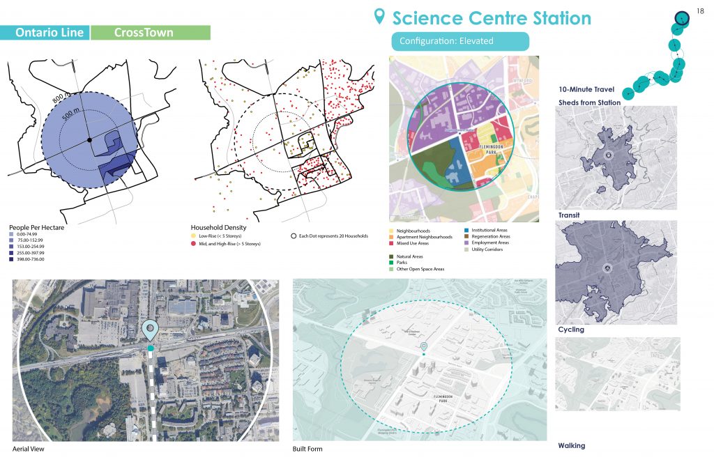
The Ontario Line – Station Overview
A station-by-station planning overview for the Ontario Line
Urban Pairs for Mattamy Homes
A low-rise multifamily model achieving 91–94% net-to-gross efficiency
Danforth Mixed-Use Main Street Infill
A 90-unit mid-rise concept that keeps small storefronts at grade while placing anchor retail above to support feasibility and main street character
Waterloo Low-Rise Family Housing Study
A low-rise housing strategy using centralized parking to unlock more family-sized units
Leon’s Regeneration Area Master Plan
A Toronto employment-land master plan turning a highway-framed site into a walkable mixed-use neighbourhood
Mini-Mid-Rise Main Street Infill
A single-lot, six-storey infill model that adds housing above retail without land assembly or underground parking
1120 Ossington Supportive Housing
A built 25-unit supportive housing project using modular mass timber
The GO Expansion Project – Station Overview
A station-by-station overview for development opportunities around GO Expansion stations
Ritson School Public Land Master Plan
A 5.3-acre public land plan near Oshawa GO, creating a flexible path for mixed-income housing
Dundas Edward Centre Mixed-Use Intensification
A downtown asset strategy expanding the office floor plate from 11,000 to 19,000 sq. ft. while adding residential density above
Aurora Mews Townhouse Development
An approved townhouse project using shared mews
Oshawa East Mixed-Use Development
A 770-home, 600,000 sq. ft. rezoning concept with commercial uses, pedestrian links, and a green plaza connecting to the ravine system
Oakville GO Station District Plan
A transit-oriented master plan connecting density, public realm, movement, and storytelling into a clear long-term growth vision
Laneway Rowhouses for Urban Infill
Turning underused laneway parking into family-sized missing middle housing
Toronto Transit Capacity Study
A city-wide housing capacity study showing how transit-accessible land could support millions of new homes and a more equitable growth strategy
GO Bike: Toronto Rail Corridor Cycling Network
An OAA SHIFT-winning infrastructure proposal for more than 100 km of safer, faster, grade-separated cycling routes along rail corridors
Let's Connect About Your Project
We use cookies to ensure that we give you the best experience on our website. If you continue to use this site we will assume that you are happy with it.
Ok
No
Privacy policy